


Northwest Ordinance Realized 1787


Treaty of Paris 1783
After the American Revolution, the Treaty of Paris 1783 was signed and the new country of America was was officially recognized. The British ceded land north of the Ohio River in article 2 of the Treaty. The question to the new American country was how do admit or create new states since the 13 original colonies already recognized each other. Article 1 of the Treaty specifically acknowledges the United States as well as lists each of the 13 states individually.

Ordinance of 1784
On March 1st, 1784, Thomas Jefferson submitted his “Report of a Plan of Government for the Western Territory”, establishing the entrance procedures of new states resulting from the cessions of Great Britain as well as the previous American colonies. He had many proposals for the new territories to include how many states would be created, the names of each new territory and a response to slavery. "Mr. Jefferson had vainly tried to secure a system of government for the Northwestern territory. He was an emancipationist and favored the exclusion of slavery from the territory, but the South
voted him down every time he proposed a measure of this nature."*
"The defeat of Mr. Jefferson’s antislavery clause was re- garded at the time as a great calamity: but Northern men soon saw that it was a most fortunate circumstance ; for if slavery had been allowed to get a foothold in the territory for
sixteen years, it could not have been abolished at the end of that period."

Northwest Ordinance
1787
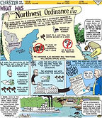
The Northwest Ordinance passed on July 13, 1787 under the Articles of Confederation. The Northwest Ordinance established the official steps the territories would need to complete to be admitted as states to the union. The boundaries of the territories as well as the names were established: Ohio, Indiana, Michigan, Illinois, Wisconsin and Minnesota. Many of Thomas Jefferson's original proposals were applied including surveying the land, some of the state names, and slavery would not be allowed in the new territories. " Thus the great States of Ohio, Indiana, Illinois,
Michigan and Wisconsin, a vast empire, were consecrated to freedom, intelligence, and morality. Thus the great heart of the nation
was prepared to save the union of States, for it was this act that was
the salvation of the republic and the destruction of slavery."*
The Declaration of the Cessation of Arms followed the Preliminary Treaty of Peace, which appears in Ben Franklin's copy book in French.
United States Congress, March 1, 1784, Printed Resolution on Western Territory Government; with Notations by Thomas Jefferson
An ordinance for the government of the territory of the United States, North-west of the river Ohio.

Mapping the Northwest Ordinance
Now learn in 8 minutes
how the territories
were established
by surveyors.

1780 Map of the United States
Original 13 colonies and key cities.